|
|
|
| by Zwei | Bier | en | DMZ: Dora, Panmunjom, Kaesong |
 |
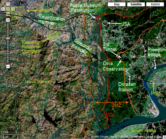 (Click map to change size.) The most challenging image task was to find the edges of the DMZ ("Demilitarized Zone") itself. It seems not to run exactly where the Google map shows. Instead you have to try to distinguish the many roads and rivers from the road with the fence along it. The DMZ is nominally four kilometers wide. Its middle is the armistice line itself, the Military Demarcation Line, or MDL. One interesting feature of the DMZ is that for considerable stretches there is heavy vegetation within it that ends at the northern edge. This may indicate security measures just outside the DMZ or heavier land use for farming. Despite the fact that no one is supposed to be inside the DMZ (it is heavily mined) I was originally perplexed by the fact that there seem to be villages within the Zone near Dora. In fact there is indeed a village on the southern side where a small number of long-time residents are permitted to continue living and farming. To be equal, the North built their own village, but apparently have not populated it with working farmers. Our bus tour stayed strictly outside the DMZ on the South Korean side (right and bottom edges of diagram). Nonetheless, the tour was within a security area, starting at the river's edge. In Imjin, south of Freedom Bridge we boarded our tour bus at the assigned time and took our assigned seats. The bridge was sprinkled with obstacles, forcing the bus to weave down the road like a drunken armidilllo. One across, we visited in turn Dorasan Station, Dora Observatory, and the 3rd Tunnel. The bus continued through the security zone to the east and northeast to swing by the bus driver's house and to a place to shop for souvenirs, before returning to Imjim. Dora Observatory is atop Mt. Dora. Wikipedia tells us: "According to legend, the last king of Silla, King Gyeongsun, dwelt nearby after he gave up his throne to Taejo of Goryeo. Unable to return to Silla, King Gyeongsun would walk to the top of Dorasan and weep for his home in Gyeongju." From Dora observatory, we could just make out the huge South Korean flag that flies opposite a North Korean flag. The South's pole and flag are huge, but the North would not be outdone and built the world's tallest flagpole (160 m). Supposedly we would have looked beyond the flags and seen Panmunjom. To the west we would have seen Kaesong. As it was we could see a lot of fog and little more. King Gyeongsun might have pined the more to have seen nothing. The 3rd Tunnel is a tourist access into one of the four tunnels that the South has found piercing the DMZ. It is quite deep and hewn from the solid rock of the mountain. I tried to sudy the imagery to find the northern end of the tunnel, but had no luck. Somehow the tons of tunneled rock were spirited away. It took me too much time to find Panmunjom on the satellite images, even though it stands out clearly if you know where to look and what to look for. Reading up in Wikipedia, I discovered that Panmunjom is not what to look for. The original village and treaty camp are long gone except for the "Peace Museum" marked on the map. The latter was built in two days to house the treaty signing and is now maintained by the North as the Peace Museum. Today, any negotiating to be done is done in the Joint Security Area about a kilometeer to the east of the Peace Museum. When not busy rattling nuclear missiles, the North has been engaging in better relations with the South. A portion of the city of Kaesong has been designated an Industrial Region with special tax provisions to encourage investment. Around a dozen South Korean concerns have set up shop in the Region's Industrial Complex and are employing North Koreans. Access is via a major road parallel to the Geongui Railroad shown on the map. The satellite image is curious: all of the highway is intact except for two 30 meter stretches just inside the South Korean side of the DMZ. There trucks must exit the highway and travel over half a kilometer on a dirt road. Just within the Northern edge, there is some kind of barrier, perhaps tollbooths, but probably tank stoppers. (There are tank stoppers across the highway outside the Southern security zone. Huge weights suspended over the roadway to be dropped to deter the advance of tanks.) North and South Korea have concluded an agreement to open the Geongui line, and work on the connection has been completed. The trains could run. One side or the other has, however, failed to give final approval, so the line sits idle. From the DMZ outside Panmunjon, through the middle of Kaesong, and on to Pyongyang runs the Reunification Highway. Four lanes. If relations ever do ease, this would be the Northern section part of a major North-South artery. For now, it is largely idle, just like the roads west from Shanghai (factories set too far away to hide their polution) and Cancun (tolls too high). In building this map, I relied on these Wikipedia references: Dorasan, DMZ, Panmunjom and JSA, Kaesong. The base map is Google satellite imagery. |
| Copyright © 2016 ZweiBieren, All rights reserved. | Mar 22, 2016 01:42 GMT | Page maintained by ZweiBieren |


|